Subscribe now for full access and no adverts
Baltinglass, in Co. Wicklow, Ireland, is well-known for archaeological echoes of early Neolithic and particularly middle Bronze Age activity, but traces of a human presence between these periods was noticeably scarcer – so much so that it had long been thought that the area was abandoned for the intervening period of prehistory. Recently published analysis of aerial imagery produced using LiDAR scans has completely transformed this picture, however, picking out topographical traces of monuments long-destroyed by ploughing, and revealing a much busier prehistoric landscape than was previously assumed.
The findings of the study – led by Dr James O’Driscoll of the University of Glasgow – are published in full in the journal Antiquity (see ‘Further reading’ below), and we summarised some of the key aspects in a news story in CA 412; here we will describe the most important discoveries in greater detail, and delve deeper into Dr O’Driscoll’s interpretations and their implications for our understanding, in particular, of an especially enigmatic form of monument: the cursus. These long, narrow earthwork enclosures (shaped like a musician’s tuning fork) are well-known from middle Neolithic Britain, and around 25 have been identified in Ireland, but this latter group have not been systematically studied, and only one (at Newgrange, Co. Meath) has been excavated.

Cursuses are a key part of the ‘cultural package’ that Neolithic migrants from Continental Europe brought to Britain and Ireland around 4000 BC. As well as new concepts like farming, pottery production, domestic buildings, and communal tomb-building traditions that completely transformed earlier hunter-gatherer lifestyles (see CA 290), this more settled way of life heralded the construction of enormous new monuments, dominating landscapes and placing an unmissable stamp on their surroundings. Cursuses begin to appear c.3500 BC, and while their outlines are impressive, their intended function has long been lost to memory.
Invaluable new insights have therefore been provided by Dr O’Driscoll’s study, which was based on LiDAR undertaken by Bluesky Ltd in the summer of 2022, as part of a project (funded by the Department of Housing, Local Government, and Heritage Community Monuments) to explore the condition of the local historic environment. The resulting imagery was closely examined to learn more about known archaeological sites and identify new ones – efforts that proved illuminating, as they have now doubled the number of monuments recorded for the Baltinglass area. Typological analysis of their outlines has revealed a diverse range of dates represented by the remains, with new discoveries including a 42ha Bronze Age hillfort, later prehistoric ring barrows, and early medieval ringforts.
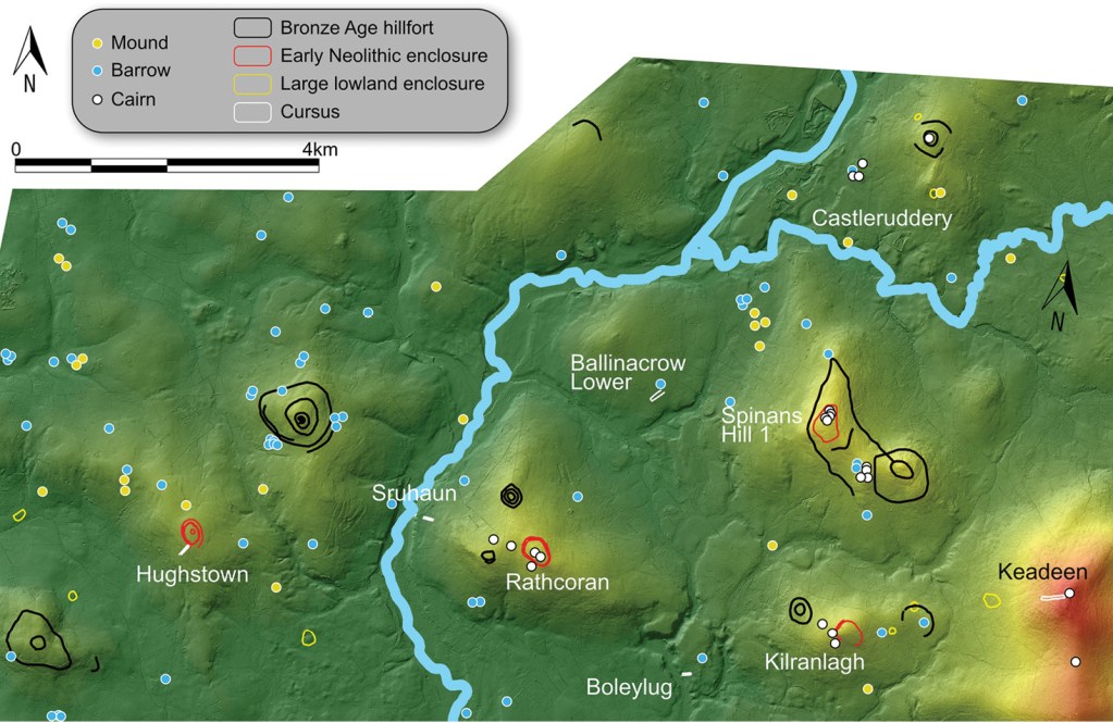
One of the most important outcomes of the project, however, was identifying a group of five cursuses concentrated within an area of just 10km by 4km. This is one of the largest known clusters of this monument type in all of Britain and Ireland, offering an exciting opportunity to explore their design and orientation in more detail – and perhaps to tease out clues as to why they had been built.
Exploring earthworks
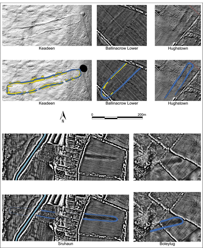
Of the five newly discovered cursuses, the best-preserved example crowns the flat summit of Keadeen Mountain. Its outline can still be clearly seen in LiDAR imagery, picked out by a bank and internal ditch, with hints of an external ditch, too. It was impressive in scale, running to some 303m in length and 32-43m wide along its course, and it is oriented on an east–north-east axis. This means, Dr O’Driscoll observes, that when the sun rises behind Keadeen Mountain on the summer solstice, the cursus is flooded with light.
Over at Boleylug, a second cursus was identified close to a tributary of the River Slaney. It is smaller than that on Keadeen Mountain, measuring 113m in length and 24m wide, but its parallel banks are clearly visible in LiDAR imagery. Strikingly, it follows the same alignment as the Keadeen Mountain cursus, its east–north-east orientation apparently carefully chosen to point towards a saddle of land between two hillocks, over which the sun rises at the autumn equinox.
The third cursus in the group was spotted at Sruhaun, at the base of Tuckmill Hill. Its western end has been truncated by the construction of modern housing, but its eastern portion survives as a 131m-long pair of parallel banks spaced 29.5m apart, ending in a semi-circular terminal. It is possible that it had originally been much larger, however: Dr O’Driscoll notes that there are hints that the monument’s outline had actually crossed the River Slaney, continuing on the other side to complete a full length of 427m. Its outline runs east–west, pointing towards a series of cairns and a causewayed enclosure – and, Dr O’Driscoll highlights, when the sun rises over Tuckmill Hill at the autumn equinox, it breaks the crest of the hill in line with this orientation.
A similar situation appears to have been factored into the design of the fourth member of this cursus cluster, which was recorded at Ballinacrow Lower. There, broadly parallel banks spaced 54.5m apart can be seen running north-east–south-west along a river terrace for 185m, with traces of an internal ditch visible along the edge of the northern bank. This monument appears to point towards a cluster of possible Linkardstown-type burials (cists covered by mounds) which are visible from the north-eastern end of the cursus – and, at the summer solstice, the sun rises in line with that long axis.
The fifth cursus in the group differs markedly from this apparent pattern. Measuring 171m long and 29.8m wide, it does not appear to have been aligned on a significant solar event. It is, however, the only one in the group to interact with another kind of monumental prehistoric construction: its outline butts up against the southern side of a causewayed enclosure at Hughstown.
Interpreting alignments
What, then, can be said about the bigger picture presented by these intriguing monuments? For those more familiar with British cursuses, which are predominantly associated with lowland settings (often in conjunction with rivers), their upland placement is striking. This context is not out of character for Irish cursuses, however: while they have not been studied in detail as a group, we can say that these monuments show much more diversity in their choice of location, having been identified at the base of hills, at coastal sites, on mountaintops, and sometimes navigating very steep topography. They tend to range in size from 78m to 950m in length, albeit with a notable concentration around the 100m-350m mark, an average that fits the Baltinglass sites well.
Something that is particularly striking about the Baltinglass sites is the apparent importance of solar events in their alignments: of the five, two appear to have been deliberately sited to point towards the summer solstice sunrise, and two towards sunrise at the autumn equinox – both important points within the growing and harvesting seasons. This is not a new idea: it has long been observed that the sun appears to have been important in the alignment of many Neolithic monuments. At Newgrange, for example, the inner chamber of its famous passage tomb is illuminated by the rising sun on the winter solstice, while the nearby Newgrange cursus is aligned on sunrise at the spring equinox. To take a British example, Stonehenge has long been associated with solar alignments, and the cursus that runs close-by is aligned on the sunrise at the summer solstice.
Given the massive investment in time, labour, and resources that such monumental constructions represent (possibly far beyond the scope of a single community, perhaps hinting at mass gatherings coming together for a shared cause), they must have been very deliberate creations, Dr O’Driscoll writes. Their alignments, too, were surely not random. As they are all linked to important events in the farming calendar, could they be associated with celebrations marking points on these cycles? Their length and linear form could also invite speculation that cursuses were intended to formalise ceremonial routes. However, Dr O’Driscoll puts forward the suggestion that these routes were not designed primarily for the living, but for the dead, representing symbolic links and pathways connecting both worlds, with their interiors intended as a shared space along which mourners could accompany the dead towards their final resting place.
The frequent association between cursuses and rivers (including three of the Baltinglass examples) might be part of this picture, he writes, suggesting that the waterways could have been sacred starting points for such journeys: ‘ritually charged liminal places with further significance’. With so many cursuses apparently deliberately designed so that the sun would rise in line with them, might this event represent the final ascent of the dead person to their next life, their perceived rebirth, or a blessing from observing ancestors? Such suggestions must necessarily be speculative, but this study offers thought-provoking insights into a possible interpretation for an enigmatic monument type – and highlights the value of LiDAR in archaeological research, and how much more might be gained by a more systematic study of all the cursuses identified in Ireland to-date.
Further reading:
James O’Driscoll (2024) ‘Exploring the Baltinglass cursus complex: routes for the dead’, Antiquity 98 (399, June): 636-653. The articles is available to read open-access at https://doi.org/10.15184/aqy.2024.39.
All images: J O’Driscoll