Subscribe now for full access and no adverts
How do we best conceive the deep past? For some, bygone events can be brought alive through the medium of stories and detailed descriptions – for others, the process will be mostly visual, perhaps represented by maps, reconstruction drawings, replicas, and even re-enactments. This isn’t very surprising when you discover that neurodevelopmental scientists tell us that approximately one quarter of the population conceptualise mainly in words, about a third use predominantly visual thinking, and the remainder utilise a mixture of words and images.
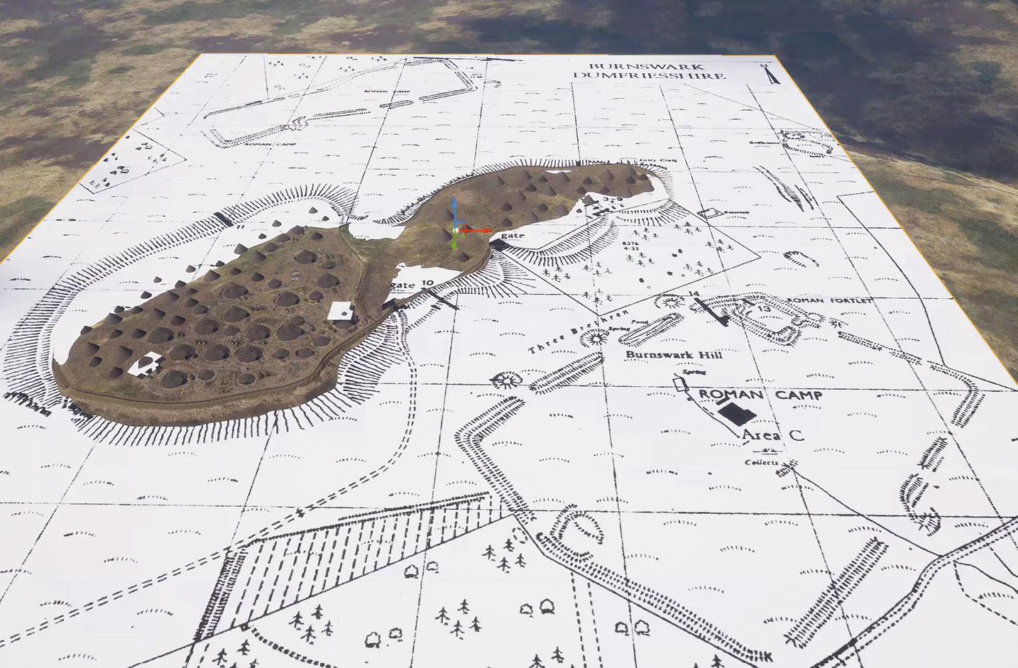
So, when the Trimontium Trust was looking for new ways to depict the complex events that took place during the Roman invasion of what is now modern Scotland, in its recently refurbished museum in Melrose (see CA 386), it opted for state-of-the-art 3D modelling to create the imagery that would give visitors an enhanced experience of what life was like for soldier and civilian during this turbulent period.

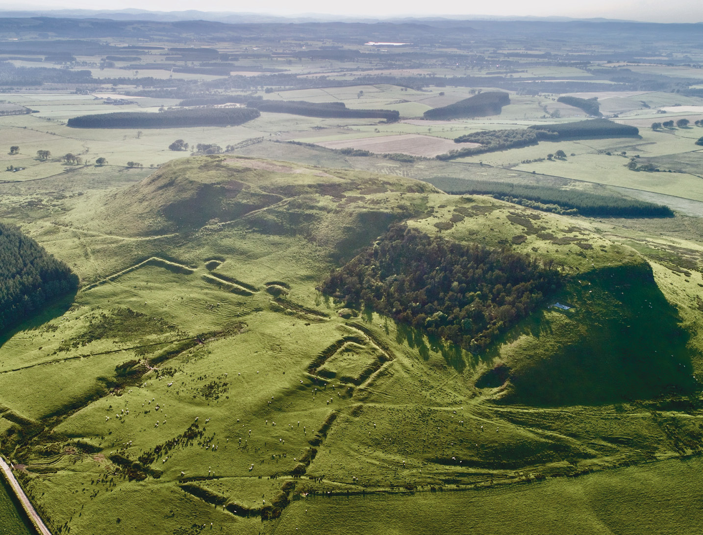
Now the Trust has been working in collaboration with Robert Gapper of Virtual Histories, to find a contemporary way to tell the story of the complex and tumultuous events that surrounded the Roman siege of Burnswark Hill in Dumfriesshire. The site comprises a 17-acre hillfort – the largest in south-west Scotland – which lies in the deadly grip of two massive Roman assault camps, an ancient but still graphic portrayal of the use of disproportionate force. The complex of surviving earthworks, unique in Europe, is also a monumental testament to this period of the Empire’s aggressive expansion and to the formidable single-mindedness of Roman military engineering.
From the outset, it was decided to base any reconstruction of what may have taken place on the published archaeology – not only the highly detailed ballistic mapping carried out by the Trust (CA 316), but also earlier evidence uncovered by George Jobey in the 1960s, R G Collingwood in the 1920s, and D Christison and J Barbour in the 1890s. Wherever possible, modelling would use the available survey data, ranging from the macro (natural features like gradients, watercourses, and residual Roman and indigenous earthworks) to the micro (gateposts, roundhouse post-holes, gateway flagstones, and the find sites of individual Roman weapons). All these data points would prove helpful in adding weight to our understanding of the choreography of the action. Underpinning this information would be a completely new terrain model generated by the Trust’s lead archaeologist, Professor Stuart Campbell, who captured the striking topography in sub-metre photogrammetric detail using the Trust’s RTK drone. This allowed the checking of excavation plans and their rectification to reflect the surviving remains.
Populating the landscape
Once the basic landscape had been established, but before further reconstruction could get under way, a few key assumptions needed to be considered and agreed by iterative discussion, starting with what phase of the Roman invasion to set the reconstruction in. For a long time, it had been assumed that the event was related to Gnaeus Julius Agricola’s initial advance into Scotland in the late AD 70s, at the behest of the Emperor Titus (r. AD 79-81), but pottery and coin finds from Jobey’s investigations on the summit of the hill had suggested that native occupation had ceased at some point significantly later in the 2nd century. In support of this, the Trust’s analysis of the type of sling bullets used for the bombardment, which were almost exclusively made of lead, pointed to the Antonine period – indeed some of the ammunition was isotopically identical to securely dated bullets from the closest Roman fort at Birrens.
Based on these findings, it was suggested that this attack on Burnswark Hill in fact represented the opening conflict of the second recorded invasion of Caledonia by the Roman army (commencing sometime in the late 130s), involving troops led by an imperial legate, Quintus Lollius Urbicus, on the orders of Antoninus Pius (r. AD 139-161). Urbicus, recently returned from Judea after playing a major role in Hadrian’s brutal suppression of the Bar Kokhba revolt (AD 132-136), was a man who clearly had considerable experience of dealing with recalcitrant foes and also delivering large imperial projects. This hypothesis goes some way to explaining the impressive investment in Roman resources involved at Burnswark Hill and the dating of some of the finds.