

Subscribe now for full access and no adverts
Excavation along the A428 in Bedfordshire has uncovered evidence of Iron Age and Roman settlement close to Tempsford. The investigations were carried out by Museum of London Archaeology (MOLA) and Cambridge Archaeology Unit, working on behalf of National Highways as part of the A428 Black Cat to Caxton Gibbet improvement scheme, with approval from Central Bedfordshire Borough Council. Although signs of fleeting Neolithic and Bronze Age visits were found in the form of flint arrowheads, the earliest evidence of settlement at the 2.3ha site (known as Field 44), consisted of postholes marking out the footprints of two large roundhouses, which have been dated to the middle Iron Age (c.300-100 BC). Each building measured over 15m in diameter, and sat within a D-shaped enclosure with a droveway, said Dr Steve Sherlock, Archaeology Lead for the road scheme (and Archaeology Manager for the completed A14 improvement works between Cambridge and Huntingdon; see CA 339). Pottery and a hearth were found in the centre of one of the roundhouses (below), which was perhaps a domestic dwelling, Steve told CA, while the other roundhouse site produced loom weights, indicative of craftworking.
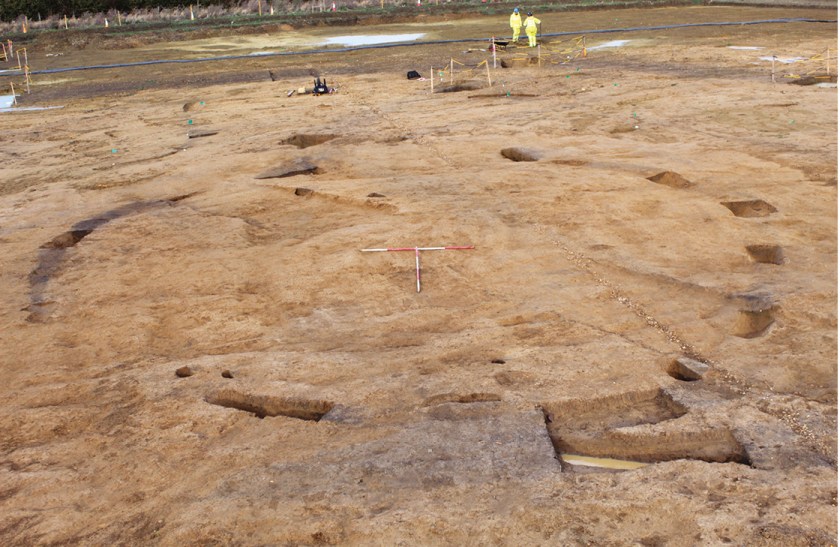
‘The D-shape of the enclosure abuts a linear feature which runs north-south,’ he added, describing a prominent sequence of ditches uncovered by the team last winter. Drawing comparisons with previous works carried out along the A14, where archaeologists have found similar linear boundary features, Steve said, ‘You get these linear, string settlements of long-distance, potentially territorial boundaries with features abutting them, joining them, and running off them.’ He explained that this ‘suggests a level of social organisation,’ adding that the Field 44 ditches may have been used as tribal territory markers, perhaps indicating that Iron Age tribal identities began forming in Britain earlier than typically suggested.
The site continued to be occupied and agriculturally significant into the late Iron Age and throughout the Roman period, when a rectangular, timber post-built structure was erected. In addition to two Roman inhumations (oriented east-west), the team also unearthed a 1st- to 2nd-century AD pottery kiln. Several contemporary failed pots were also uncovered, alongside further 3rd- and 4th-century finds, including a malt kiln or corn dryer, and a large millstone grit rotary quern.
How should we interpret this apparently long-lived settlement, which has been suggested to be a farmstead? In answer, Steve highlighted the presence of another Iron Age settlement a kilometre to the north: a smaller, oval-shaped enclosure with one internal structure, which the team will be excavating in due course. Its proximity to Field 44 is suggestive of a complex agricultural landscape, he said, citing models of farmstead development gleaned from his excavations along the A14 to explain that some Iron Age and Roman farming landscapes can be thought of as wheel-like. ‘There’s a central hub, which becomes a distribution point,’ he said. ‘On the A14, we could see droveways leading out to smaller farmsteads where they were growing crops and bringing their surpluses into the centre, where they were processed and distributed out. And we see this site in Field 44 as one of these central hubs – It’s larger, it’s better developed.’
Work along the route of the A428 continues in 2022; meanwhile, post-excavation analysis of Field 44 is under way. ‘The lessons we learn and the samples we collect here will inform how we should be sampling and doing further work,’ Steve said. Find out more on MOLA’s new podcast, ‘Highways to the Past’ (https://highwaystothepast.buzzsprout.com), or on Facebook and Twitter (#A428BlackCat).


