ORIGINALLY PUBLISHED SEPTEMBER 22, 2017. UPDATED SEPTEMBER 22, 2021.
For more than 4,000 years the Great Pyramid has drawn people to Giza. The largest pyramid currently standing anywhere in the world has borne numerous names across the millennia and inspired countless stories. For two Arab authors, writing after the 3rd or 4th century AD, it was a monumental repository raised by the legendary King Surid to safeguard the wealth and wisdom of Egypt from flood and fire. A few hundred years earlier, Greek and Roman tourists celebrated it as a wonder of the ancient world, while the historian Herodotus offered a damning verdict on the antics of its builder, whom he called Cheops. Perhaps the most prosaic writings concerning the pyramid are also the earliest. These take the form of funerary inscriptions, graffiti, and even a journal penned by those toiling to construct it in the 3rd millennium BC, during the reign of Pharaoh Khufu. It is the name for the pyramid coined by its creators that has also proven most prophetic: the Akhet Khufu or ‘Horizon of Khufu’.

Today, the horizon at Giza is one of the most recognisable in the world, thanks to the three close-set, pharaonic pyramids silhouetted like serrated teeth against the skyline. Of these monuments, the middle one – with its pinnacle still clad in fine limestone casing – often appears the largest, but this is no more than a trick of perspective. This edifice overlies the tomb of Khufu’s second son, Khafre, while the smallest of the ‘big three’ Giza pyramids was commissioned by Pharaoh Menkaure. He is believed to be Khafre’s son, and Khufu’s grandson, but time ran out on Menkaure before his resting place was complete. His demise resulted in the lower part of the pyramid bearing lumpy, unfinished, granite casing stones, producing a somewhat rustic finish. Despite such concessions to speed, these grandiose funerary monuments, probably raised over the course of about 70 years during what Egyptologists call the 4th Dynasty, have overshadowed Giza, both literally and figuratively, ever since.
Despite the impressive scale of the pyramids, there has always been more to Giza than these immodest monuments. Traces of the first activity on the plateau have been all but wiped away by quarrying and later burials. Even so, both earlier pottery found in the vicinity of the Great Pyramid and three grandiose tombs just south of the Giza plateau, pre-dating Khufu’s dynasty, suggest the escarpment was no blank canvas for the pharaoh’s grand design. Even during the heyday of pharaonic pyramid-building at the site, these monuments were only the most ostentatious element of an intricate suite of funerary structures. Each Pharaonic pyramid was served by an upper and lower temple, which were connected to the pyramid via a ceremonial causeway. Smaller satellite pyramids for queens could be arranged around the pharaoh’s resting place, while pits containing boats emphasise their role as ports on a voyage to the afterlife. Giza was not restricted to royalty, though, and there are also elite tombs, which were laid out like the orderly city blocks of a modern new town and contained the elite of ancient Egyptian society.
Life from death
The Egyptian mania for pyramids may have stemmed from a very simple observation. Every year, as the Nile floods receded, it was the mounds projecting above the waters that turned green fastest. This reading casts the corpses of the dead as metaphorical seeds, planted beneath their own ceremonial mounds, preparing them for renewed life. In their new book Giza and the Pyramids, Mark Lehner and Zahi Hawass show that there was far more to the plateau than mummified ranks of the elite awaiting reanimation: the living were also present in large numbers. Although their text provides an engaging and comprehensive account of the many elements that made up Giza, this article will focus on the fresh evidence that has emerged over the last few decades for the living community that developed to create and serve the cemetery. This recent work also reveals how the very act of building the Giza pyramids changed Egypt forever.

‘When I went to graduate school in Yale in 1985,’ says Mark Lehner, president of Ancient Egypt Research Associates (AERA), ‘I read the surveys of Mesopotamia, where archaeologists were taking sites like Ur in Iraq and trying to estimate the size of the population. I was dealing with the opposite situation at Giza, where Egyptologists were calculating that 20,000-30,000 people must have been present. So in Mesopotamia they had a site and were estimating the numbers of people; I had an estimated number of people, but no settlement. Where did these workers, priests, and craftsmen live? That’s the question I wanted to answer when I came back to start excavating at Giza.’
‘A couple of years earlier, I’d mapped the Great Sphinx stone by stone, and for me that project served as a key leading into a wider focus on the Giza plateau. The Sphinx sits in a U-shaped quarry and is basically a cross-section of the natural geological layering at Giza. It became clear that the stone removed from around the Sphinx had been taken, in the form of blocks weighing up to 100 tons, and used to build its temple. They left a core of stone that became the body of the Sphinx, but the upper stone – which was better quality – has mostly gone and may have been used to build the valley temple associated with Khafre’s pyramid. The point is that if, in our mind’s eye, we could build and unbuild the Sphinx and its temple, what could we do with the quarry construction sequence across the whole plateau?’
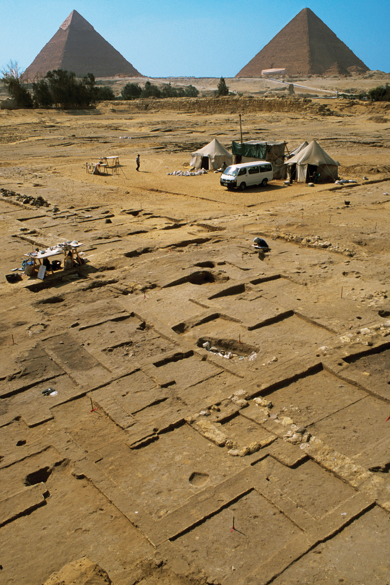
‘Due south of Khufu’s Great Pyramid there is a huge hole created by quarrying. We wondered if this hole corresponded with the “pile” – if I can put it so ignominiously – of the Great Pyramid, and in turn if the quarry could help inform us how the whole Giza necropolis developed. For that reason, we carried out a mapping project, which involved David Goodman, who is a professional surveyor and civil engineer. The grid that we established then still serves us to this day. One of the questions that came out of that work was “Well, if the hole is down there, and the pile is up there, wouldn’t it be logical for the infrastructure needed to create the pyramids to be beyond the wadi passing the mouth of the quarry?” That area was also marked by a gigantic stone wall known as the Wall of the Crow, which is 200m long and 10m wide at the base. The other side of that seemed a good place to look for the infrastructure and settlement.’