


Subscribe now for full access and no adverts
Contrary to the usual practice, it was a journal (Archaeologia Cambrensis: ‘ArchCamb’) that gave birth to the Cambrian Archaeological Association (CAA), rather than the other way around. ArchCamb was founded by the Reverend John Williams and the Reverend Harry Longueville Jones, who described themselves as ‘two poor clergymen’, and the first of four parts making up Volume I was published in January 1846. It was not until the third part was published in July 1846 that ‘A Welsh Antiquary’ proposed the establishment of a Cambrian Archaeological Association ‘for the study and preservation of the national antiquities of Wales’. The first list of 90 founder members was published in part four in October 1846, and the first meeting was held in Aberystwyth in 1847.

The newly formed CAA was one of a growing number of societies – national, local, subject-, or period-themed – founded across Britain in the 1830s and 1840s as a result of the growing interest in archaeology, which was at the time emerging from antiquarian studies as a distinct discipline that would undergo a revolution in methodology over the next 30 years, enhancing our understanding of the deep antiquity of human culture. The CAA set out with grand ambitions (many of which were later to be enshrined in the remit of the Royal Commission on the Ancient and Historical Monuments of Wales) to make ‘complete and accurate surveys, measurements, delineations, etc., of all monastic remains’, ‘all parochial churches, chapels, etc.’, ‘all castellated remains’, ‘all ancient houses of a certain degree of importance’, ‘all buildings, and other remains, or towns, villages, parishes, etc., including all public, civil buildings, etc.’, ‘including as complete an account as possible of all ancient documents, of what kind soever, relating to the five preceding classes’.
Artists’ blocks and plates
The Victorian passion for knowledge of the past was partly created – and was certainly fuelled – by technical developments in letterpress printing, such as steam presses capable of increased volumes of rapid production, machine-made paper, distribution by the expanding network of railways and a national postal system, and the utilisation, to a high level of skill and accuracy, of woodblock illustration of buildings, monuments, and artefacts. Woodblocks could be incorporated into ‘formes’ of type, locked into their chases on the press, and thus appear on the printed page with accompanying text, unlike copper and steel plates that were separately printed and had to be ‘tipped in’ to the bound volumes.
Heather James (who with Toby Driver has edited the contributions of 24 authors to produce the CAA’s 175th anniversary commemorative volume), is currently engaged in curating and cataloguing the remarkable number of surviving printers’ blocks and plates, many of them created by leading artists of the day and now historical artefacts in their own right. The cost of producing these illustrations was not inconsiderable, however. William Britnell, who has just passed on the mantle of editor of ArchCamb to Ken Murphy, says that more than £120 was spent in 1861 for 34 steel and wood engravings, in addition to costs of over £175 for printing that year’s volume (representing £14,000 and £21,000 respectively in today’s terms). That partly explains why the illustrations in early volumes were often limited to infrequent views of monuments, and drawings of finds and coats of arms.

Graphs and plans
Over the course of time, the demand for more illustrations of many and varied kinds grew to meet the desire of authors to present information and ideas about the past in increasingly detailed and sophisticated ways. Volume I introduced excavation plans, and building plans and elevations, and the editorial advised would-be contributors that:
In drawings and sketches, accuracy of detail and measurement will be esteemed far beyond picturesque effect, which is of little or no value for archaeological purposes; and in case of illustration of camps, castles, churches, buildings, or any monuments, being communicated, it is particularly requested that, if possible, a ground plan, with the proper measurements, may accompany them. The scale upon which a drawing or plan is made, ought always to be specified.


Section drawings first appeared in 1850, as did the first conjectural reconstructions, though orthographic projections and cutaway drawings did not appear until 1955. Cartography based on Ordnance Survey mapping first appeared in 1862, but the first distribution maps (introduced by Cyril Fox) only appeared in 1925. Photography made its debut in the journal in 1886 and would eventually give rise to the appearance of aerial photographs (1927), X-ray imagery (1999), and microscopy (2012). The acquisition of ever more data demanded visual presentation in graphs (1932), pollen diagrams (1960), histograms and pie charts (1978), scattergrams (1982), and radiocarbon probability diagrams (1984). Complex sequences and processes would become elucidated by flow maps (1968), flow charts (1982), and phasing matrices (2015).
Advances in print production technology, such as halftone and offset printing, have reduced the cost of publishing images and have made full-colour printing – first appearing in ArchCamb in 1994 – more affordable. Equally, developments in digital imagery have been so rapid and profound that it is easy to forget the paraphernalia on which archaeological illustration depended until quite recently – some of us still have sheets of Letraset dry-transfer lettering and Rotring Isograph drawing pens, now choked with dried ink, which today constitute museum exhibits in their own right as a record of how archaeological illustrations used to be created.


The modern world belongs to software, satellites, drones, and sonar, as digital developments and the rise of geomatics have brought about vector graphics produced by total station survey, and CAD (2006) and GIS (2013) software. Remote sensing imagery generated by photogrammetry (1992), geophysical survey (2006), laser scanning and LiDAR (2011), imagery from drones (2017), and underwater acoustics (2019), as well as computer-generated 3D visualisations (2015), have likewise been added to the archaeological toolkit.
Recording Roman roads
The earliest volumes of ArchCamb introduced the perennial obsession of many subsequent antiquaries, archaeologists, and amateurs: the hunt for Roman roads, which began at least as early as the 17th century, featuring in the Parochialia of Edward Lhuyd (1660-1709). Often in the past, any apparently ancient trackway or length of straight country lane was considered Roman and added to an ever-growing list of potential routes. Older Ordnance Survey maps are peppered with Roman roads that embody the imaginings of local antiquaries. Since then, the late Hugh Toller (1949-2016) has single-handedly redrawn the routes of many Roman roads using modern field techniques, as well as making new discoveries, such as the route of the Roman road from Castell Collen to Caersws shown on the map (below).

Even so, antiquarian records tell us much about the countryside up to 175 years ago and still have enormous value. An article by James Dearden and Harry Longueville Jones, ‘On the Roman Roads of Caernarvonshire and Merionethshire’, published in Volume I in 1846, is enlivened with descriptions of old farms, notable place-names, tumuli, standing stones, and the mention of old finds now lost.
Royal Commission aerial reconnaissance work continues the search for the complete Roman road line between Segontium and Abergwyngregyn, together with a postulated Roman fort missing somewhere south of Bangor. Indeed, it was only during aerial reconnaissance in June 2010 (below), followed by better drought conditions in July 2013, that cropmarks of the Roman road were finally revealed between Llanddeiniolen and Glasinfryn, south of Bangor.

Illustration versus photography
Historical accuracy
Henry Fox Talbot, the photographic pioneer, announced his technique of capturing images on light-sensitive salted paper in 1839, and in Wales these new developments were taken up enthusiastically by amateur photographers. But it was not until the 1870s that the ‘halftone’ process of printing photographs came into widespread use in books and journals. This sparked a debate among the reviewers of archaeological publications about the respective merits of photography versus illustration in scientific works. This wood engraving by the Cambrians’ draughtsman Worthington George Smith was used to illustrate a report on the Cambrians’ 1889 field trip to Brittany, which appeared in ArchCamb in 1890. It shows how a fine drawing can include much more information than a photograph, not least because the draughtsman has put back together what are in fact two broken and separated parts of the Neolithic menhir at Mané-er-Hroëck.

Drawing tools: the camera lucida
The camera lucida, which uses angled prisms to cast a view of the featured building or object on to the drawing board, was patented by Sir William Hyde Wollaston in 1806, based on optical principles first published by Johannes Kepler in 1611. It was in widespread use by the mid-19th century as an aid to accuracy and realism in field drawing. Worthington George Smith, the Cambrians’ draughtsman, made frequent use of the tool to aid his production of the drawings that appeared in ArchCamb. The photograph shows him at work recording excavations at the Cistercian Abbey at Strata Florida in 1887 and 1888, while the engraving was made from Smith’s drawing of the abbey’s west doorway, published in ArchCamb in 1889.
As well as producing field drawings, Smith was a skilled caricaturist. In 1892, ArchCamb included his sketch of Professor E A Freeman in typical pose delivering ‘one of his admirably lucid addresses on Gothic architecture’.


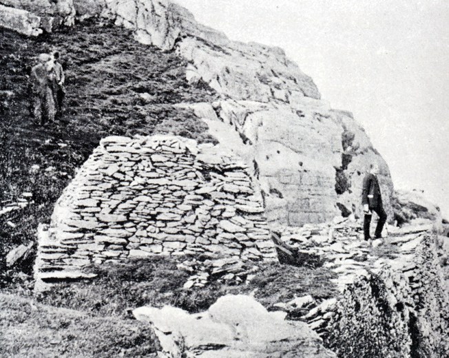
Shot of skellig Michael
Of this image, one of a series of photographs of Skellig Michael, from the report of the Summer Meeting in Co. Kerry, Ireland, 1891, Heather James writes:
The equipment needed by the late Victorian photographers still remained bulky and heavy – one can only admire the tenacity of the group of Cambrians… who were ferried out to Skellig Michael on board HM gunboat Banterer and carried their cameras up the steep rocky paths to photograph the beehive huts and other features of this oceanic monastic site.
Ecclesiastical buildings: restoration or desecration?
In the spirit of debate
The pages of ArchCamb reflect the controversies of the age over church ‘restoration’, with contributors using the book reviews section to make clear their views on ‘the desecration of churches in the name of improvement’. In the first volume, the reviewer of a newly published Guide to Abergavenny fumed:
verily, this [the description of the church] makes our wrath boil over! We would willingly take the heads of the churchwardens, bricklayers etc. of 1820 and ram them in to their own mortar and whitewash…
Elsewhere in the journal, ecclesiastical architecture was a prominent topic, and the subject for many descriptive reports, illustrated by sketches that have great value for depicting the building prior to restoration or even demolition. For example, ‘the old church at Llandysul near Montgomery’ (below), described by Longueville Jones in 1864, the year in which the church was demolished, is said to ‘present several architectural peculiarities’, including ‘a wooden belfry almost unique in Wales’.

Miscellaneous objects
The sections of ArchCamb headed ‘Miscellanea’ and ‘Correspondence’ offered opportunities for contributors to describe and illustrate individual items, to vent their feelings about ‘church sacrilege’, to petition for funds to assist church restoration, and to share information about newly recognised features of interest. Two types of object attracted frequent attention in the 19th century. Fonts, their materials, and their decoration were regularly discussed, including such rarities as the wooden font at Efenechtyd, Denbighshire, depicted in this drawing (below) by Longueville Jones, published in 1872.

Brasses, sepulchral slabs, and effigies were another popular topic, one example being a drawing by Worthington George Smith of the tomb of Katherine Turberville and her husband Sir Roger Berkerolles, within the church of St Athan, Vale of Glamorgan, published in 1890. Distinctive or unique objects also merited attention: these now-lost wooden dog tongs from Clodock, Herefordshire (below), drawn and engraved by Smith and published in 1877, probably date from the 18th century and were used for removing disruptive canines during church services.

Folk culture under threat
Domestic buildings
Traditional domestic architecture in Wales was already under threat in 1902 when Romilly Allen published this drawing of the farmhouse at Trefeiddan, near St Davids, Pembrokeshire, with its round chimney, thatched main roof, and aisle-like slate-roofed outshuts. He reported:
in 1883, there were several old farmhouses with round chimneys still in existence… but since then they have disappeared one by one, so that in a few years it is probable that there will not be a single example left. It is desirable, therefore, that some record should be kept of a style of domestic architecture which is rapidly becoming obsolete. My chief regret is, that I did not take more notes and measurements of the buildings before they were swept away… but I did not anticipate that the process of demolition, once begun, would go on so quickly.

Traditional crafts and customs
Folk life, including traditional crafts and customs, was considered a quaint curiosity in the 19th century, with articles being published more for their novelty value than their academic interest (and mainly for an English or Anglicised Welsh audience). Rarely was any attempt made to gain an understanding through direct contact with the people who practised them, but Matthew Moggridge (1803-1882) of Swansea did his best with his 1851 paper ‘On the Preservation of Local Traditions’, calling for members to record the traditions of their own area. Not one person contributed. When E L Barnwell made a similar plea in 1855, again little was published. It was only towards the end of the 19th century that an interest began to be shown in practices that were then beginning to decline, including sin-eating, bidding marriages, the placing of flowers on graves on Palm Sunday or Easter Sunday, burial customs, ancient graveyard games, the (Welsh) dresser, and wooden spoons and spoon racks.

Among the objects that were considered fit for publication were the Llangower ‘horse-bier’ (above), described in the 1884 edition of ArchCamb as resting ‘emeritus and fast decaying, under the shelter of a fine old yew in the churchyard… The almost solitary specimen of its kind’, and St Beuno’s Chest (published in 1868; below), made from a single piece of oak and the subject of the Welsh saying for attempting a very difficult thing: ‘You may as well try to break up St Beuno’s chest’.


A fine spoon rack with a withy handle from St Davids was illustrated (above) in an article in 1895 on carved wooden spoons made in Wales – and fortunately survived as an exhibit (below) in St Fagans National Museum of History.

Further reading
Heather James and Toby Driver (eds),
Illustrating the Past in Wales: a celebration of 175 years of Archaeologia Cambrensis 1846-2021 (Cambrian Archaeological Association, £7.50, ISBN 978-0947846091; 80pp). To order copies, visit the Cambrian Archaeological Association’s website: www.cambrians.org.uk.
All images: Cambrian Archaeological Association, unless otherwise stated.


